History of Marracuene and Macaneta
Country |
 Mozambique Mozambique
|
Province |
Maputo Province |
District |
Marracuene District |
Mozambique - A History
Mozambique is an African country found on the east coast of the continent that has experienced a colourful and often turbulent history since the Portuguese explorer Pedro da Covilha set anchor in the present day city of Beira in 1487. The only country along this coastline to be colonised by the Portuguese, the name Mozambique is thought to have been derived from the name of one of the first Arab traders “Sultan Mussa Ben Mbiki”.
The Country
Mozambique spent almost five centuries as a Portuguese colony, which ended in 1975, although an ongoing civil war, economic dependence on South Africa and crippling drought meant its development was hindered until the mid 1990s.
The ruling party, the Front for the Liberation of Mozambique (Frelimo), officially abandoned Marxism in 1989. After this the party adopted a new constitution in 1990 and opened the way for multiparty elections and a free market economy. While the civil war raged on during this time, a UN-negotiated peace agreement between Frelimo and the rebel Mozambique National Resistance (Renamo) forces, formally brought an end to the fighting in 1992.
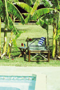
Marracuene and Macaneta
Macaneta is a peninsula island just 33km north of Maputo and forms a part of the Marracuene district within the Maputo province. Earlier known as Vila Luísa, Marracuene is situated on the Incomati River.
According to the history books February 2, 1895, Marracuene was the site of a decisive battle between Portuguese commander António Enes and Ronga emperor Gungunyane. The Portuguese defeated the larger Ronga forces by means of repeating rifles and a machine gun and the anniversary of the battle is celebrated by the locals each year.
The district of Marracuene has a surface area of 703 km2 and an estimated population of approximately 61 000 inhabitants. The name Marracuene is popularly believed to refer to the original owner / operator of the riverboat transportation crossing between the mainland and Macaneta. His name was Muzrakwene, the security chief for the then king Maphungaa.
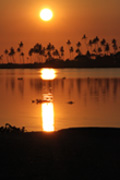
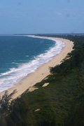
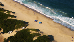
Since the discovery of Mozambique by its colonial tenants, Marracuene and in fact Macaneta itself was considered a popular tourist destination due to its 33.8km long beach on the Indian Ocean. Formerly the town also served as a key link in the Lourenço Marques Railway System and a key port in this popular trade route.
Macaneta forms the peninsula of Marracuene and is made up of a narrow band of sandy ground stretching in a northerly to southerly direction approximately 12km in length, 2kms wide, at an altitude of 65m. It forms the barrier between the Incomati river estuary and the Mozambique channel.
The beaches of Macaneta are magnificent, perhaps the reason it was a favourite colonial holiday destination, and on a short trip when on the island south to Ponta da Macaneta, you will find an old shipwreck and catch a glimpse of Xefina Island.
Today Mozambique is a peaceful country with a growing economy, it is an ideal tourist destination with a fantastic culture, cuisine and a melting pot of people.
|